
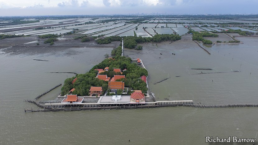
A Thai Temple in the Sea

As each year passes it becomes increasingly more difficult to find new and interesting tourist attractions not far from Bangkok. I have been on some really good day trips that have included renting a boat to go dolphin watching, riding a train that literally passes through a market, and the Reclining Buddha image where you can go inside to see the heart. I didn’t think that there would be much more of interest which hadn’t been discovered already. Then I saw a television programme about Wat Khun Samut Chin on the Gulf of Thailand. I had first heard about this Thai temple surrounded by the sea in a newspaper article in the Bangkok Post about four years ago [2003]. I wanted to go there back then, but there are no roads in this area and the only mode of transport is by boat. It seemed incredibly difficult. So, I just put the name of this temple up on my whiteboard with the other destinations I wanted to visit. Seeing the temple on television last month and then also recent newspaper reports about land erosion statistics released by the World Bank, prompted me into renewed efforts into finding out how to reach this small community on the coast.
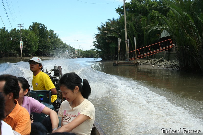
Through some research, I discovered that there was a public boat to Ban Khun Samut Chin leaving the pier at the Paknam Market at about 9.15 a.m. every day. Apparently there is only one boat going and one returning at 3 p.m. I had been warned to take my own food and drinks and to be careful not to miss the only boat to return. There are no hotels or restaurants there so I would have to be self-sufficient [There are now homestays]. My first two attempts of catching this boat failed miserably. On each occasion the boat left earlier then the scheduled time. On the second time I was there extra early at 8.40 a.m. but had just missed it. Talking to some of the locals there, they suggested that I should catch the passenger ferry to the other side and try and rent a boat from there. They said it would be a lot cheaper than renting one from Paknam Pier. So, that is what I decided to do the following weekend. Though, instead of catching the ferry across the river, I decided it would be easier if we drove over as then we could drive around looking for a place to rent a boat.
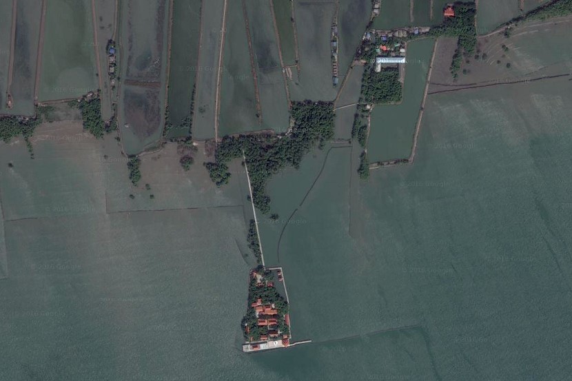
Looking on the Google Earth satellite pictures of this area, I could see that Wat Khun Samut was directly south of Ban Sakhla which I had visited the other year. The road to this town, in the middle of no-where, had only been paved a couple of years ago. We decided we would take the car there in order to find a boat. But, we only got half-way down this road when we suddenly spotted a sign advertising boats for rent. As there are no roads south of here, local people can only get around by renting a boat. Unless of course, they have their own boat. We were informed that the cost would be 110 baht one way for the boat. This wasn’t bad considering that there were four of us and that the public boat from Paknam Pier would have cost us 40 baht each. We were soon heading south down a canal lined with short stumpy nipa palms. Here and there we passed isolated houses with their own private jetty’s. There were also a number of long-tailed boats ferrying people back and forth to various destinations. But overall, not much sign of any kind of activity.
During our journey they were several sharp turns both left and right. After about ten minutes we reached a small jetty where our boatman told us that we would have to disembark. He said that we would have to continue the remainder of the way on foot. He gave us his mobile phone number and said that we should ring him when we were ready to return. We then scrambled up onto the bank to see our first view of the surrounding countryside. What I had seen earlier on Google Earth made me think that this whole area was covered by neatly laid out rice fields. But, in fact, they were all shrimp “fields”. Basically, long narrow man-made ponds with embankments in-between each of them. There must have been hundreds of shrimp farms as far as they eye could see in all directions. Greenpeace had conveniently blamed Global Warming for the land erosion along this coastline. I am not an expert in these matters, but I would say that the erosion is probably more to do with the local farmers cutting down the mangrove forests and then inviting the sea to come and fill up their fields.
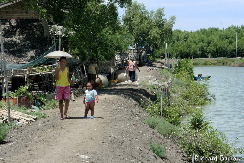
After walking for about ten minutes we reached the first house of Ban Khun Samut Chin. This belonged to Khun Samron Kengsamut, who is the head of this community. She wasn’t in at the time but her son kindly opened up the museum for us so that we could see some of the broken crockery and other artifacts that had been discovered in this area. He also showed us some pictures and maps and told us that over the last 20 years or so the sea had encroached on the land by about one kilometer. As we were about to leave, he asked whether he could take our picture. As this was a little strange, because we weren’t celebrities, I asked him exactly how many tourists came this way. He replied that they get at least two or three a week. I guess taking pictures of every visitor will only discontinue once the idea of tourists coming here is no longer a novelty.
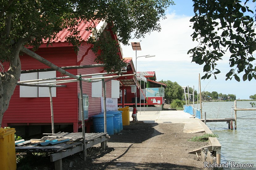
Walking down the track, we next passed a building painted in a bright red colour. This houses a Chinese Shrine called Noom Noi Loi Chai which the local fishermen worship. Apparently, this had already been moved once due to land erosion. Walking further we passed a number of wooden shacks. Some of them looked deserted. There were of course no 7-Eleven’s but there were also no shops of any kind. We felt like that we were intruding on this community and we wanted to give something back by buying something. Even if just a bottle of water. But, there just wasn’t anything. Of course, I can see this changing as soon as this location gets into the guidebooks. If I come back here in a year or two, I can just imagine that this dirt track will be paved and every other house will be restaurants and souvenir shops. Much like Koh Kret in Nonthaburi has become today. [Nine years later, there are a couple of houses selling food and two homestays. It’s still a dirt track.]
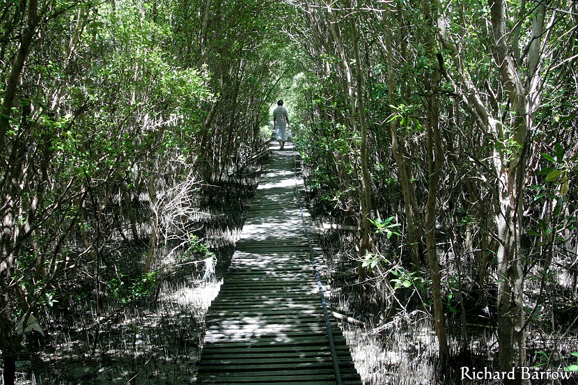
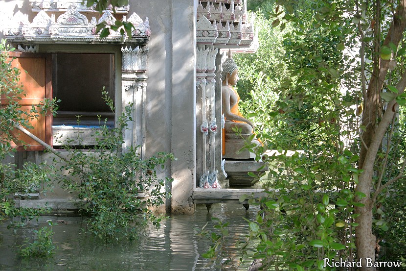
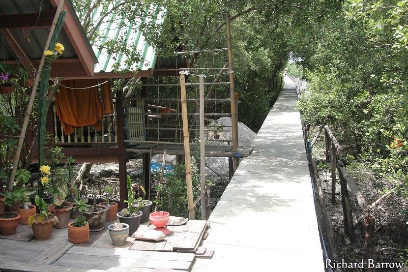
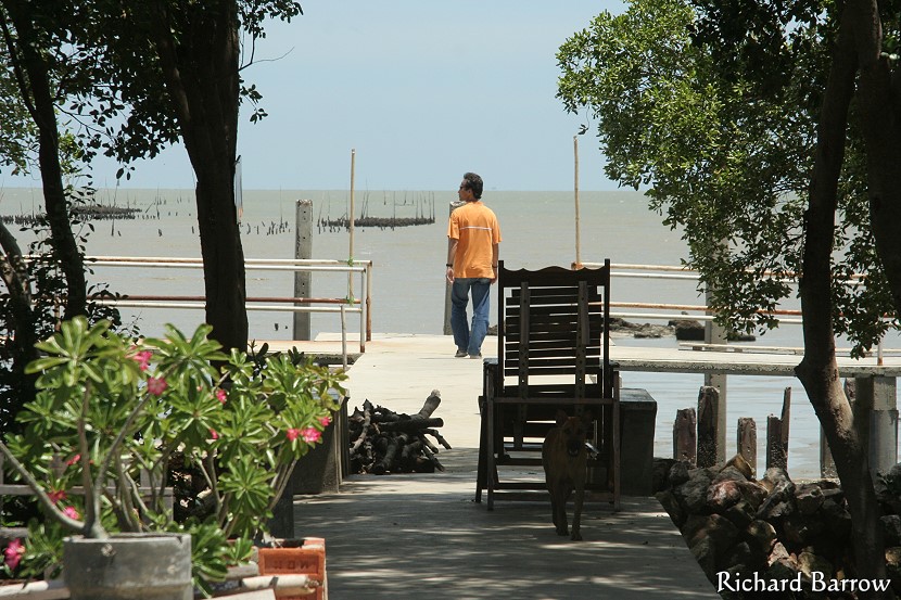
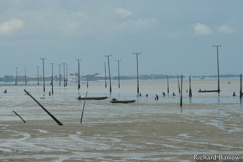
We walked along the outskirts of several shrimp fields and then walked on a rickety wooden walkway through a mangrove forest. [This is now a concrete walkway]. After about twenty minutes of walking we finally emerged at the edge of the Gulf of Thailand. Straight ahead of us was a new concrete raised walkway with the temple in the distance surrounded by trees. To our right I could see where the locals had planted saplings as part of their reforestation plan. Evidence of the land erosion could be clearly seen by looking out into the Gulf of Thailand. A line of electricity pylons stood testament that there was once a thriving community under these waters. A bit further I spotted the remains of a concrete water tank that used to belong to the local school. I am also told that out there somewhere are the remains of the local clinic.
The total distance from the boat jetty where we started our walk to the temple was 1, 644 metres. As we arrived at the temple the first structures we passed were the kutis, the accommodation for the five resident monks. These were built on stilts in order to stay above high tide. A bit further I spotted the crematorium on our left and then the open sala where the local people would come to meet the monks. We were met by the village chief. Her son had phoned ahead to say that we were on our way. They had apparently just finished eating and invited us to sit down and have some food. We weren’t really that hungry as we had a late breakfast not that long ago. But, they were insistent and started spreading out food on the floor in front of us. As it would have been rude to refuse, we sat down to tuck into a very delicious meal.
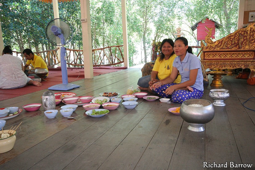
While we were eating, I asked Khun Samron about the local community. She told us that due to the land erosion, there were now only 400 people left in Ban Khun Samut Chin. A reduction of about 30% compared to about 20 years ago. There are now only 70 houses. She said that she herself had moved her house three times. Her mother had moved five times in the last thirty years. Many people had given up and had now moved away. This has led to limited human resources for the community such as doctors and dentists. The local school now only has 30 students which shows that most of the young families have moved away. Their other problem is that many of them have a title deed to land that no longer exists. Their future is looking bleak.
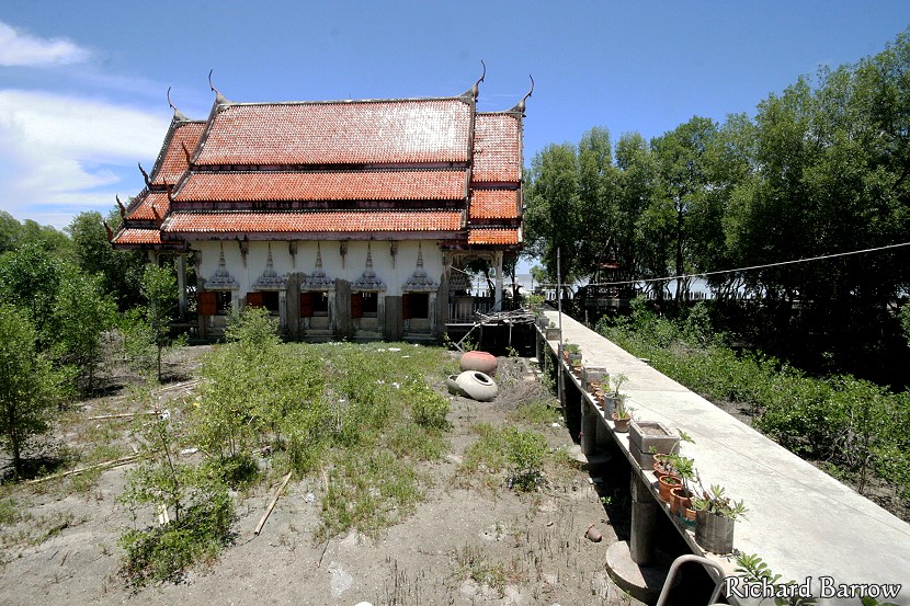
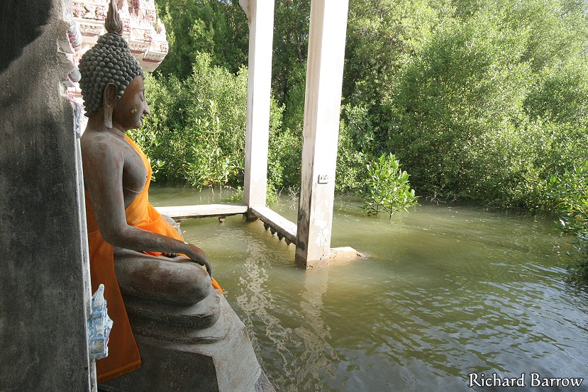
After eating, Khun Samron then invited us to go and take a look at the temple. They have now built a raised walkway that took us to the temple. In that Bangkok Post article, I had seen a photo of people jumping from water jar to water jar in order to reach the temple. Shame in some ways that they are no longer here. But it is understandable that the most convenient method is used now. During our visit it was low tide and so there was only mud around the temple. Nothing like the dramatic pictures I had seen on the poster for Global Warning. I am told it is only like that during the monsoon season and only at high tide. The day we went it wasn’t high tide until 8 p.m. So, I don’t really have any “dramatic” pictures to show you. However, their story is dramatic enough.
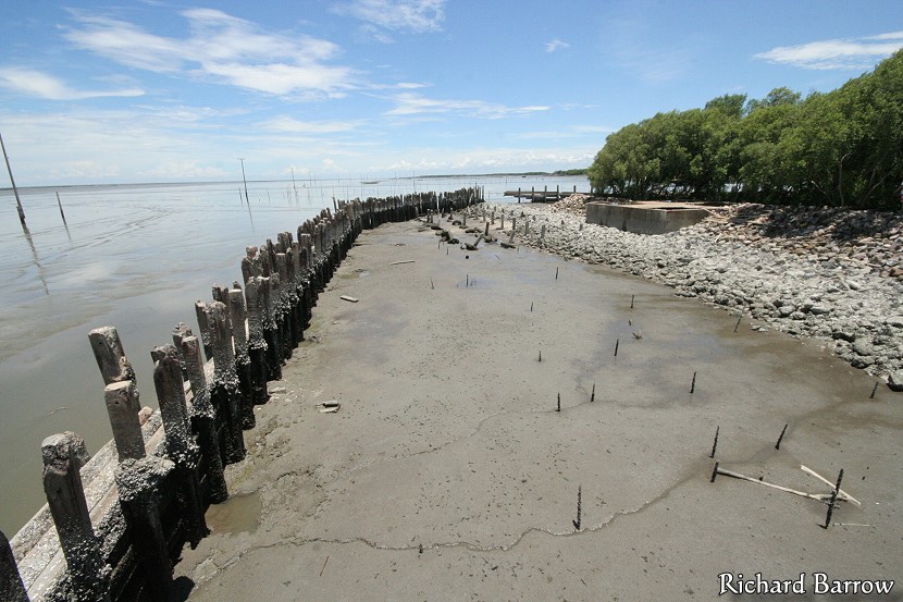
We decided to save the temple to last and walked straight past it to the jetty. Here we could see the concrete pillars that had been drilled into the soft mud in order to provide a breakwater. The sea wall seemed to be working to an extent as sediment had built up on the far side resulting in the water level on that side being higher. But, more is needed to make it more effective. We could also see evidence of where the monks and other local people had been planting saplings. Mangrove forests are nature’s way of stopping land erosion. In the distance we could see many more of the telephone and electricity poles. Also we could see concrete structures that were probably the remains of community buildings.
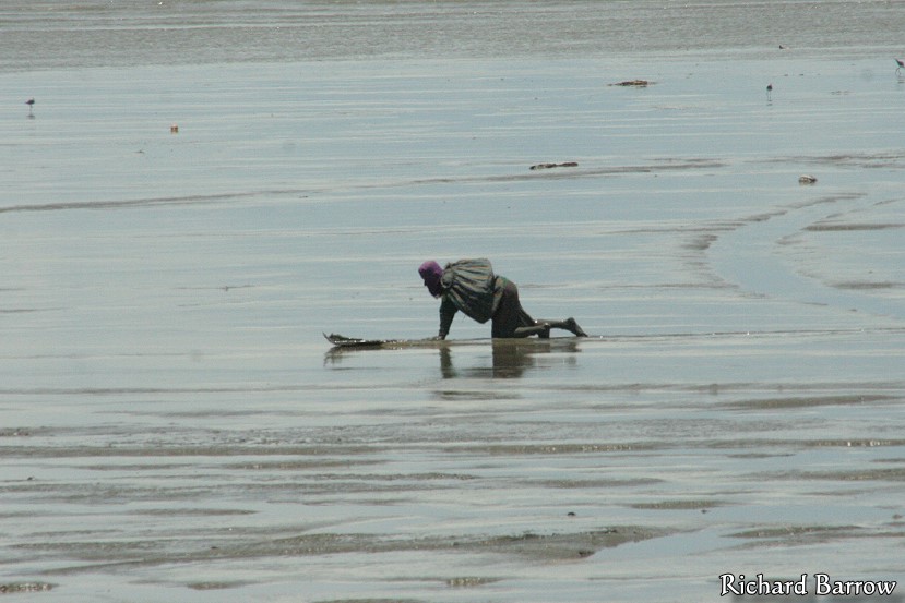
I had said earlier that most people around here seemed to be shrimp farmers. But, looking out to sea, I could see quite a few people out on surfboards. No, I don’t mean that they were surfing on the waves. They were using flat boards to skim over the surface of the mud in order to look for cockles. This is a traditional method that goes back hundreds of years. Some modern versions use boats which kind of ploughs the sea bed digging up the cockles. But these have been accused of ecological damage and I am glad that they are not being used here. I could see small boats further out, but I was told that they were looking for plankton to be used to make a shrimp paste.
There had been a heavy storm earlier in the day. Now there was a clear blue sky and a refreshing sea breeze. It was extremely pleasant and we decided to just sit there for a while and enjoy the sea air. I can see why the locals were keen to stay here. Before, when I was thinking about catching the public boat here, I was worried that I wouldn’t have anything to do all day. I would have to stay here for nearly five hours waiting for the public boat to return. But, as it turned out, we were there for over four hours anyway just hanging around. I think I will come again soon so that I can spend the day exploring the area a bit more. And I could always bring a book to read.
After resting, we decided to take a closer look at the temple. Really, it is an ordinary looking temple though with an extraordinary history. It has developed from a religious symbol for the local community to one for their fight against the threat of land erosion. While all other buildings, both private and government, have moved further inland, it is the temple alone that has refused to relocate. Though, of course, compromises had to be made. The kutis where the monks slept were rebuilt on stilts. The temple building itself couldn’t be raised. However, what they did do was raise the level of the floor by about a meter. They have also blocked the lower half of the windows. So, to look out of the window, you have to sit down on the floor.
To enter the temple from the front, there is a gangplank that we used to safely cross without getting our feet muddy. During high tide, there would be a moat of water around the building. As the once grand entrance had now been halved, I had to dip my head as I entered. I was almost hesitant to take off my shoes because of the condition of the building and floor. But, the Buddha images were all arranged close to the floor and tradition dictates that we should humble ourselves by bringing ourselves as close to the physical floor as possible. We could see straight away that there must have been a fair amount of damage to the interior design. The whole inside of the building had been whitewashed. Though, with gaps everywhere, it looked like someone was either in a rush or ran out of paint. Leaning against the wall behind the Buddha statues were the original hand carved wooden doors that could no longer hang from the smaller doorframes.
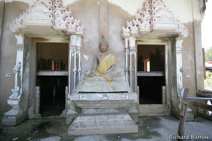
At the back I jumped down from the raised floor to the ground to take a closer look at a Buddha image that was standing guard there. Despite the battering it had received from the monsoon weather, it was still in relatively good condition. Looking under the raised floor boards, I could only see mud in the dim light. However, at the far end, I could just make out the pedestal for a large Buddha image. This was probably made from concrete and couldn’t be moved up. So they just raised the Buddha image up onto the new wooden floor. Around the temple I could see where they had planted saplings over the years as the mangrove forest was of varying ages. At least they were doing their best to stop the waves eroding the foundations of the temple. But, it might all be too little, too late.
Before we left, we went to say a farewell to the village chief. She was only too happy that we had come to visit her community. She got her camera out and took a picture of our group. Before I parted I gave her a print out from Google Earth showing this area. She seemed pleased because it was far greater quality than what she had seen before. She excitedly picked out individual houses saying who lived where. It would be interesting to see satellite pictures of this same location five years ago. Then we could clearly see the rate of progress of the land erosion. Some experts put it at least 5 meters of erosion per year in this year. Others say more.
As we parted, I promised that I would help spread the message of the plight of the villagers and their fight against land erosion. I also said that I would be back later this month in order to explore the area more thoroughly. [I have been back to this community many times. In 2016, I cycled here for the first time from my home in Paknam. See my trip report here.]