
Paknam Market

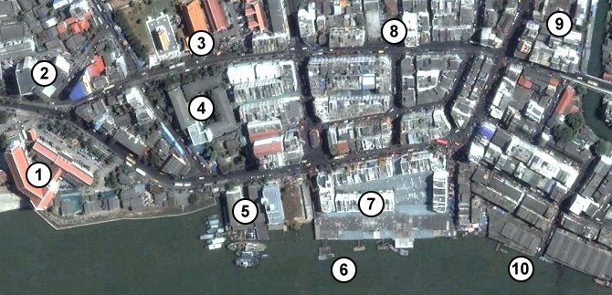
Showing the area around Paknam Market. North is to the left of the picture.
[column-group]
[column]
(1) Provincial Courthouse
(2) Samut Prakan Police Station
(3) Wat Pichai
(4) Wat Pichai School
(5) Fisheries Department
[/column]
[column]
(6) Crossriver Pier
(7) Paknam Market
(8) City Pillar
(9) Racha Night Food Market
(10) Fishing Jetty
[/column]
[/column-group]
This is basically the city center for Paknam. The two roads at the top and bottom of this pictures are the main shopping streets. The city has a one way system. You enter the city on the top road which passes Wat Pichai and the City Pillar. This then goes as far as Taiban circle where you can return on the bottom road which passes the fishing jetty and the market. You will find many bus stops along the road between the Fisheries Department and the Courthouse.
[column-group]
[column]
OLD MAPS
- Samut Prakan 1954
- Samut Prakan 1948
- Samut Prakan 1935
- Samut Prakan 1912
- Phrakhonchai Fort in 1904
- Paknam Railway Map 1954
- Paknam Railway Map 1937
- Old Map of Paknam
[/column]
[column]
SATELLITE MAPS
- Ban Sakhla
- Phra Samut Chedi
- Crocodile Farm
- Taiban Circle
- Paknam Market
- Samut Prakan City Hall
- Samut Prakan City
- Samut Prakan Estuary
[/column]
[column]
GOOGLE MAPS
- Forts in Samut Prakan
- Tourist Attractions in Samut Prakan
- Temples in Samut Prakan
- Golf Courses in Samut Prakan
- Map of Paknam Railway
[/column]
[/column-group]